Hello, all! I was in the process of making a map of the US, which involved laying polygons over each state, all with different colors. When coloring the states, though, some of the borders of the polygons of the states overlapped each other, making it look a bit funky. Perhaps there is a way to make all the borders the same color so this doesn’t happen, leaving only the center of the state colored?
It would be extremely helpful if someone could help me out with this-- with the exception of this minor issue, this mapping tool is perfect for what I need!
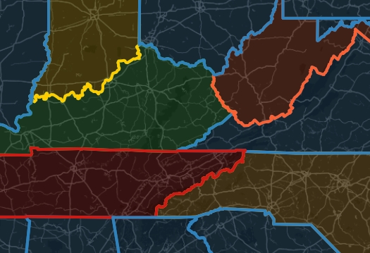
An example of what I mean is provided below-- notice how much of Kentucky’s outline is overcrowded with the outlines of other states.
Yes, being able to edit the outside color separate from the inside color would fix the problem I’m having. It would also be helpful if I could change the opacity of the fill / inside color of the polygons (make it more or less transparent). Thanks for the quick response!
Sorry to be a bother, but do you have an idea of when these features might be implemented (ballpark)? I might need to rework my update schedule on my website now that i plan on using your maps… No rush (of course), Im just trying to figure out how to make this transition work. Thank you so much for your time and patience!