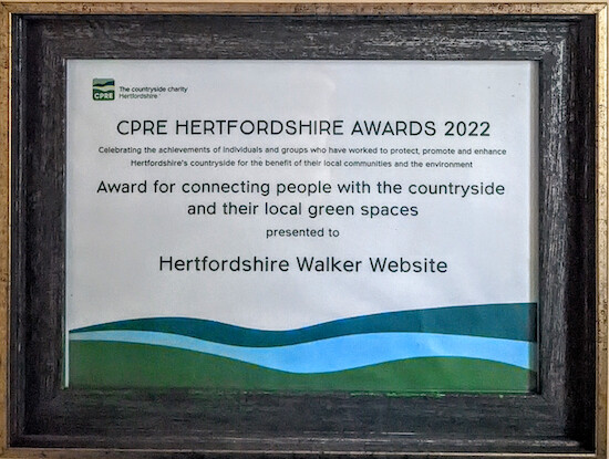
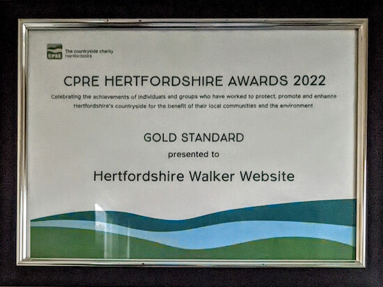
Last week my site, Hertfordshire Walker, which currently has 218 free walks in Hertfordshire, was presented with two awards by the countryside charity CPRE Hertfordshire.
I am certain that this wouldn’t have been possible without MapHub. Every page on my site containing the walk directions includes the following from MapHub.
A small MapHub map
Linking through to a full-size MapHub map
An embed of the interactive map for the walk
A GPX file
A KML file
The combination of all these MapHub products played a massive part in helping my wife and I win these awards.
That’s fantastic David, you’ve really put a whole lot of wortk into this. Love the detail that you’ve gone to overlaying pics with your own direction arrows to show better the route to take. Very impressive overall, no wonder you received awards.
Been using maphub for Biodiversity village and wildlife reporting at a local level here, turning out to be very useful, but nowhere near as to the scale you’ve managed.
Earlier this year I was able to help in a similar project to this one, but for a pdf booklet of paths. Ended up using maphub too, but not as detailed at all. https://www.pkc.gov.uk/media/49518/Walking-the-Perth-Kinross-Council-Core-paths/pdf/WalkPKCPBookFINAL.pdf?m=637858801155000000 We credited Maphub on each image, though it’s quite difficult to read it.
Weren’t allowed to use Ordnance survey mapping, so thank goodness for Open Street Map and Maphub.
You’ve really gone to town. Well done.
Wow, Patrick, that pdf is a wonderful piece of work, and a great use of MapHub. Impressive. It makes me want to plan a holiday up there. And I love the detail you have added, including the footpath names and numbers. I find the more detail the better in terms of helping walkers keep to the route.
Are you going to put those walks online so they can be accessed on mobile? I am sure they would get used.
I use the free Google Blogger tool. It’s easy. And you have already done all the hard work.
If you did you could include the Maphub GPX files for each walk so that people could download them and follow the walks on their smartphones using a free sat nav app such as Komoot, or the paid-for OS app. The GPX files are extremely popular feature on my site. Regular walker love them.
And you could also include a link to a larger version of the static maps (as I have done, giving users the option of clicking on the smaller map to reveal a larger version).
And you could embed the interactive map, that MapHub generates, in the walk directions.
If you do decide to put those walks online and need some advice feel free to contact me. Happy to try to help.
Gee whizz David, I didn;t think that all that would be possible, never imagined in fact.
Like you say, the hard work’s already been done.
Well, I’ll have a play around over at your Hertfordshire Walker site and take it from there - slowly Working on establishing a biodiversity village at the mo, may be quieter round Christmas.
Thanks David, unfortunately, for now that’s as far as I’ve got. The map’s for a presentation at our conservation meeting tomorrow evening (in the local Tavern!) where our group will meet Conservation Officers from Fife Coast & Countryside Trust, hoping that they will take the lead on our Bio Village plans. After tomorrow evening I’ll start to overlay features from this map onto our village conservation map, so that we have both plans and species sightings on one map along with work we’ve carried out so far.
If you want to find out more about the Biodiversity Villages concept, the Tayside Biodiversity Partnership have recently added a toolkit to their website.
I use the free version of the Relive app. You either walk with it running on your phone or import a GPX file or a walk and it does it for you. If you want to import a GPX file from MapHub to Relive you have to first import the GPX to the free Komoot and then upload to Relive. Neat, isn’t it. People who are planning to do my walks love it.